Dronetag Scout
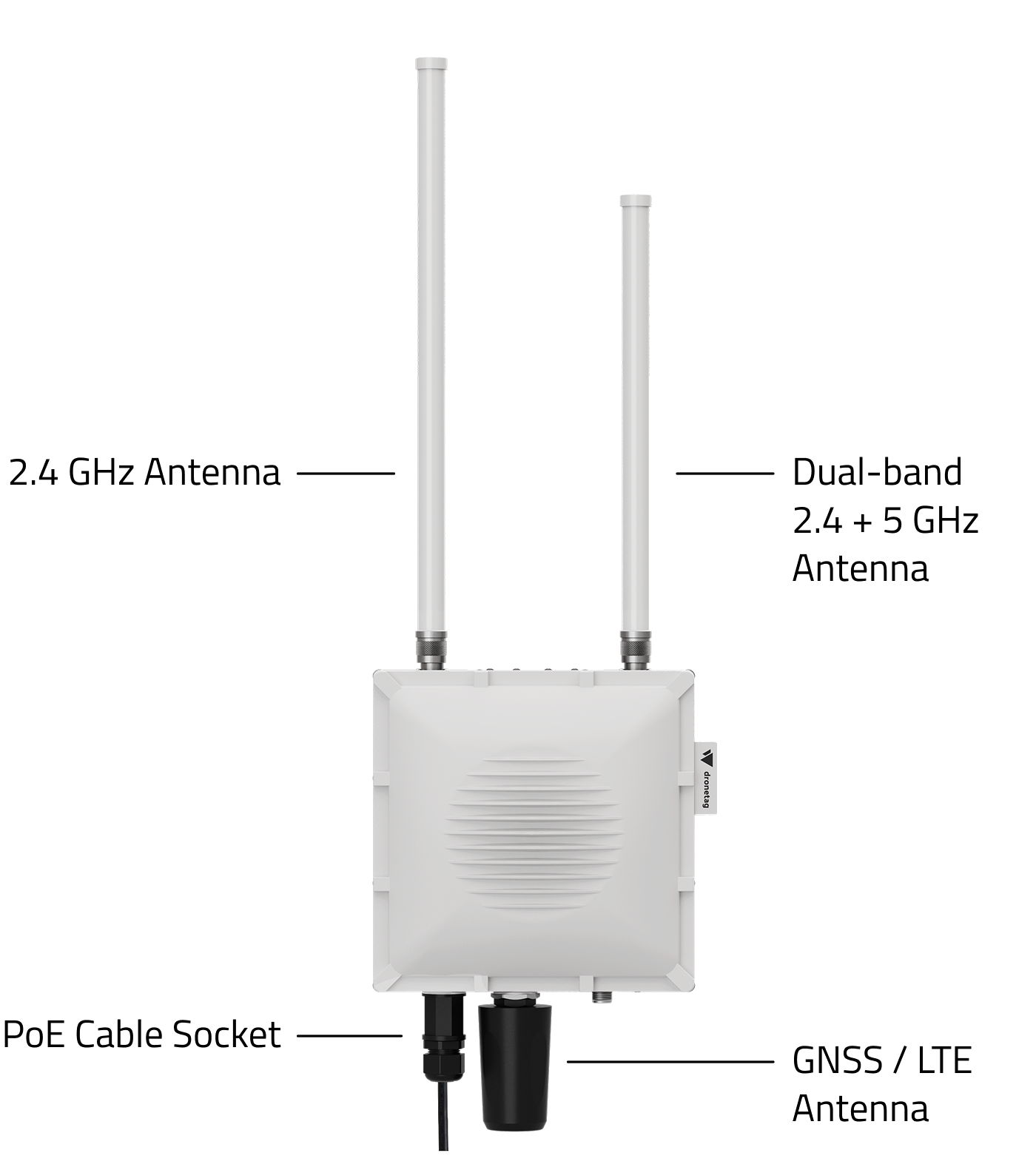
Dronetag Scout is a stationary Remote ID receiver, designed to detect compliant drones within its coverage area, providing robust operational awareness. Remote ID technology enables the identification and tracking of drones that meet regulatory standards, enhancing situational awareness and safety in shared airspace.
With Dronetag Scout, users can monitor drone activities, receive real-time data on drone identification, location, heading, speed, height (barometric and GNSS), status, take-off location, and operator location - helping ensure compliance with local airspace regulations. Its stationary design is ideal for fixed installations, offering a reliable solution for consistent, real-time insight into drone operations in the vicinity.
Dronetag Scout supports all Remote ID technologies Wi-Fi Beacon, Wi-Fi NaN, Bluetooth 4 Legacy and Bluetooth 5 Long Range (LE Coded PHY) for Remote ID detection.
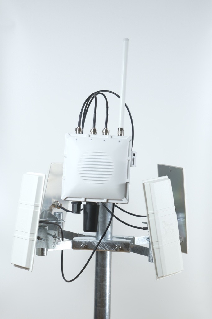
- On this photo is Dronetag Scout with One Dual-Band Omnidirectional Antenna, Four Directional Antennas and Holder for Four Directional Antennas.
What Scout Detects
The Dronetag Scout is drone-agnostic and captures all Broadcast/Direct Remote ID data from drones that comply with Remote ID standards, such as DJI, Autel, and Skydio - up to 10 km in the EU, US, and Japan (with more regions expected to adopt these standards soon). The data can be sent in real-time to the Dronetag App for data visualization and airspace alerts or can be sent raw to third-party platforms without Dronetag apps being involved. It works regardless of whether the drone has built-in Remote ID capabilities or uses an external module.
Please note: the Scout device detects only Remote ID signals - if the drone does not broadcast any Remote ID, the Scout will not detect it.
Here you can find all information about Remote ID.
In countries where Remote ID is not mandatory, Scout can only detect drones that have an active Remote ID transmission (for example: Canada, Australia, New Zealand, and others).
Keep in mind that Remote ID broadcasting behavior depends on each drone’s firmware version and location awareness.
Many drones use their built-in GNSS position and firmware rules to automatically enable or disable Remote ID transmission depending on the country they are currently flying in.
This means that the same drone may be detectable in one region but not visible in another, depending on whether its firmware recognizes that Remote ID regulations apply in that specific airspace.
For detailed and actual list of Remote ID compatible drones, please, contact the official agencies:
Remote ID Requirements by Country (as of October 2025)
| Country / Region | Status | Effective Date | Notes | Source |
|---|---|---|---|---|
| EU / EASA framework | ✅ | 2024-01-01 | Mandatory Direct Remote ID for specific category and class-marked in open. | EASA (easa.europa.eu) |
| Austria | ✅ | 2024-01-01 | Under EASA framework | EASA |
| Belgium | ✅ | 2024-01-01 | Under EASA framework | EASA |
| Bulgaria | ✅ | 2024-01-01 | Under EASA framework | EASA |
| Croatia | ✅ | 2024-01-01 | Under EASA framework | EASA |
| Cyprus | ✅ | 2024-01-01 | Under EASA framework | EASA |
| Czech Republic | ✅ | 2024-01-01 | Under EASA framework | EASA |
| Denmark | ✅ | 2024-01-01 | Under EASA framework | EASA |
| Estonia | ✅ | 2024-01-01 � | Under EASA framework | EASA |
| Finland | ✅ | 2024-01-01 | Under EASA framework | EASA |
| France | ✅ | 2024-01-01 | Under EASA framework | EASA |
| Germany | ✅ | 2024-01-01 | Under EASA framework | EASA |
| Greece | ✅ | 2024-01-01 | Under EASA framework | EASA |
| Hungary | ✅ | 2024-01-01 | Under EASA framework | EASA |
| Ireland | ✅ | 2024-01-01 | Under EASA framework | EASA |
| Italy | ✅ | 2024-01-01 | Under EASA framework | EASA |
| Latvia | ✅ | 2024-01-01 | Under EASA framework | EASA |
| Lithuania | ✅ | 2024-01-01 | Under EASA framework | EASA |
| Luxembourg | ✅ | 2024-01-01 | Under EASA framework | EASA |
| Malta | ✅ | 2024-01-01 | Under EASA framework | EASA |
| Netherlands | ✅ | 2024-01-01 | Under EASA framework | EASA |
| Poland | ✅ | 2024-01-01 | Under EASA framework | EASA |
| Portugal | ✅ | 2024-01-01 | Under EASA framework | EASA |
| Romania | ✅ | 2024-01-01 | Under EASA framework | EASA |
| Slovakia | ✅ | 2024-01-01 | Under EASA framework | EASA |
| Slovenia | ✅ | 2024-01-01 | Under EASA framework | EASA |
| Spain | ✅ | 2024-01-01 | Under EASA framework | EASA |
| Sweden | ✅ | 2024-01-01 | Under EASA framework | EASA |
| Iceland (EASA) | ✅ | 2024-01-01 | Under EASA framework | EASA |
| Norway (EASA) | ✅ | 2024-01-01 | Under EASA framework | EASA |
| Liechtenstein (EASA) | ✅ | 2024-01-01 | Under EASA framework | EASA |
| Switzerland | ✅ | 2024-01-01 | Harmonized with EASA rules | EASA |
| USA | ✅ | 2024-03-16 | Mandatory under 14 CFR Part 89 (except in FRIA areas) | eCFR / FAA (ecfr.gov) |
| Japan | ✅ | 2022-06-20 | Registration and Remote ID functionality mandatory | MLIT / JCAB |
| Singapore | ✅ | 2025-12-01 | B-RID required for UA > 250 g | CAAS / Singapore Government |
| South Korea | ✅ | 2024-01-01 | 2024-01-01 | MOLIT / Korea Government |
| United Kingdom | ✅ | 2026-01-01 | Direct RID required under UK regime | CAA UK |
| Canada | ❌ | — | No national broadcast RID mandate to date | Transport Canada |
| Australia | ❌ | — | Under consultation for future Remote ID, no mandate yet | Australian Infrastructure / Govt |
| India | ❌ | — | Digital Sky / NPNT system in place, broadcast Remote ID not declared | DGCA India |
Features
Remote ID Compatibility
Supports Bluetooth 2.4 GHz (4 Legacy and 5 Long Range) and Wi-Fi Beacon / NaN Remote ID technologies across both 2.4 GHz and 5 GHz bands - fully compliant with ASTM F3411-22A, ASD-STAN EN 4709-002, FAA, EASA, and MLIT standards.
Scout continuously scans all available Bluetooth and Wi-Fi channels, ensuring that no drone goes undetected - even those transmitting on non-standard or less-used frequencies.
Advanced Drone and Pilot Detection
Multiple independent radio modules operate in parallel, receiving and decoding all nearby Remote ID signals in real time.
Scout can identify:
- Active drones, their pilots (take-off locations), and manufacturers/models
- Every active Remote ID transmission in the area - with no upper limit on how many drones can be tracked simultaneously
💡 Scout can detect and visualize thousands (even millions) of drones at once, with zero false positives.
Intelligent Multi-Channel Scanning
Scout uses adaptive channel selection, automatically prioritizing the frequencies where active drones are broadcasting.
This approach ensures:
- Higher positional accuracy for each detected drone
- Continuous background scanning of other channels for new detections
- Smarter bandwidth allocation, maximizing coverage and reliability in dense RF environments
The result: precise, real-time tracking with unmatched reliability - even in signal-heavy urban areas.
Modular Design and Custom Configurations
Scout’s architecture is fully modular and can be tailored to your specific operational needs.
Choose from:
- Basic Omni Setup – compact dual-antenna system for standard operations
- Directional Antennas – directional coverage for specific zones
- 360° Multi-Directional Setup – full perimeter protection for critical infrastructure or city-wide deployments
- Expansion modules for ADS-B, ADS-L, FLARM, and others
→ enabling complete airspace awareness across both crewed and uncrewed aviation layers.
Real-Time View and Data Logging
If used in Cloud Mode, you can visualize detections instantly in the Dronetag App (Android, iOS, or Web), or integrate data into your C-UAS / UTM system via API, MQTT, webhooks and other options.
If used in Cloud Mode, all detections are automatically stored and timestamped for analysis, investigation, or evidence.
Features include:
- Live airspace view with filters and history
- Geofencing and alerts for unauthorized activity
- Exportable logs for reporting or legal documentation
Seamless Cloud Integration
When connected to the internet, Scout transmits detections securely to the Dronetag Cloud (if used in Cloud Mode) for real-time synchronization, multi-sensor deduplication, and API access.
Cloud-connected Scouts receive automatic firmware and database updates for new drone models and protocol improvements - ensuring your system always performs at its peak.
Effortless Installation
Deploy Scout anywhere with pole or wall mounting options.
Power and data are combined through PoE / PoE+, minimizing cabling and simplifying setup.
An optional 4G module provides flexible online access when wired networks aren’t available.
As a passive receiver, Scout creates no radio interference and operates silently in any environment.
Built to Last
Constructed with an IP67-rated aluminum enclosure, internal heating, and industrial-grade components, Scout runs reliably in extreme conditions from –20 °C to +50 °C.
Supports multi-GNSS positioning (GPS, Galileo, GLONASS, BeiDou) for precise localization.
Multi-GNSS Positioning & Timing
Scout integrates a multi-constellation GNSS receiver (GPS, Galileo, GLONASS, BeiDou). This module is critical for:
- 🗺️ Precise Scout location on the map - shows exactly where each unit is deployed and where signals are captured.
- ⏱️ High-precision GNSS time reference - provides micro-second-grade timestamps for every received Remote ID message, enabling tight synchronization between multiple Scouts and accurate sequencing of fast events.
- 📏 Distance & bearing calculation to detected drones - by combining the Scout’s known position with the drone’s broadcasted GNSS data, the system can compute exact proximity and direction.
- 🔒 Anti-spoofing & data validation - GNSS position/time are used to verify the plausibility of received messages (e.g., matching timestamps, expected distances and movement), helping detect spoofed or falsified signals.
Result: multi-GNSS gives Scout the geographic accuracy, timing precision, and signal integrity needed for trustworthy, high-resolution airspace monitoring.
🧠 Summary
Dronetag Scout redefines Remote ID detection with:
- Unlimited simultaneous drone tracking
- Zero false positives
- Full-band 2.4 GHz + 5 GHz scanning
- Smart multi-channel tracking logic
- Modular, scalable design
- Real-time cloud connectivity and automatic updates
- Rugged IP67 build ready for 24/7 operation
Simply put - it sees everything, everywhere, with total accuracy.
Optional Upgrades
You can enhance your Scout with custom upgrades, tailored to your needs:
- 4G Modem with SIM Card and LTE Antenna – Enable online cloud transmission for real-time data monitoring and integration.
- Directional Antennas – Improve performance in high-interference environments or extend coverage with up to 4 antennas for 360° reception.
- Older DJI Drones without Remote ID (planned feature) – Add extra sensors to detect legacy DJI models like Mini 2, Air 2, Mavic 2, Phantom 4 Pro.
- On-Premise Deployment – Operate without cloud dependency for secure, private access.
- ADS-B, ADS-L, FLARM and Other Protocol Support – Add additional aviation tech for full situational awareness.
Range
The range is defined by the Remote ID transmitter power on the drone and the environment in which the receiver is located. For this User Guide, we divided it into Detection Range and Tracking Range:
Detection Range
- Ability to sporadically pick up drone activity at greater distances.
| Antenna type | Urban Area | Rural Area |
|---|---|---|
| Omnidirectional | up to 5 km / 3.1 mi | up to 10 km / 6.2 mi |
| Directional (Sector) | up to 10 km / 6.2 mi | up to 47 km / 29.3 mi |
Tracking Range
- Real-time, continuous reception for reliable monitoring.
| Antenna type | Urban Area | Rural Area |
|---|---|---|
| Omnidirectional | up to 2 km / 1.2 mi | up to 4 km / 2.5 mi |
| Directional (Sector) | up to 5 km / 3.1 mi | up to 20 km / 12.5 mi |
Tests were based on real internal testing. Drones were flown at different altitudes and distances. A Dronetag Beacon (Bluetooth) and DJI Mavic 3 (Wi-Fi) were used as transmitters, and results comply with EU signal power regulations.
With directional antennas, both detection and tracking ranges may nearly double, depending on placement and environment. This is especially useful for installations covering a specific sector or overcoming interference.
Detection range can vary significantly based on environmental conditions, obstacles, and interference. Urban environments may cause range reductions. Learn more about factors influencing Remote ID detection.
Where to Start with Dronetag Scout
To explore what your Dronetag Scout can do and how to best deploy it for your use case, start with the overview of supported Operating Modes:
🔍 See all available modes and choose the right one for your mission
We recommend using the Scout in Cloud Mode together with the Dronetag App — it's the easiest way to set up, manage, and monitor your system. It offers full feature access including real-time tracking, data storage, alerts and remote control.
👉 Follow our guide to get started with Cloud Mode and the Dronetag App